Ocellus XR is a mixed reality application that leverages the Urban Systems Lab’s (USL) Data Visualization Platform to present users with unique interactive geospatial information of heat, flood risk and other climate indicators in New York City.
Integrating environmental studies and data visualization into place-based research on social vulnerability and equity, the app provides a novel experience to understand climate risk, allowing users to explore first-person 3D visualizations of social, ecological, and technological data by projecting interactive maps and implemented resilience interventions onto physical surfaces and experiment with augmented reality layers. The Ocellus XR project builds on the USL’s expertise in advancing spatial agent-based modeling, machine learning, social media data, and cutting-edge visualization of urban social, ecological, and infrastructure systems to ask new questions about key climate change risks and opportunities to advance adaptation in cities.
Key Features
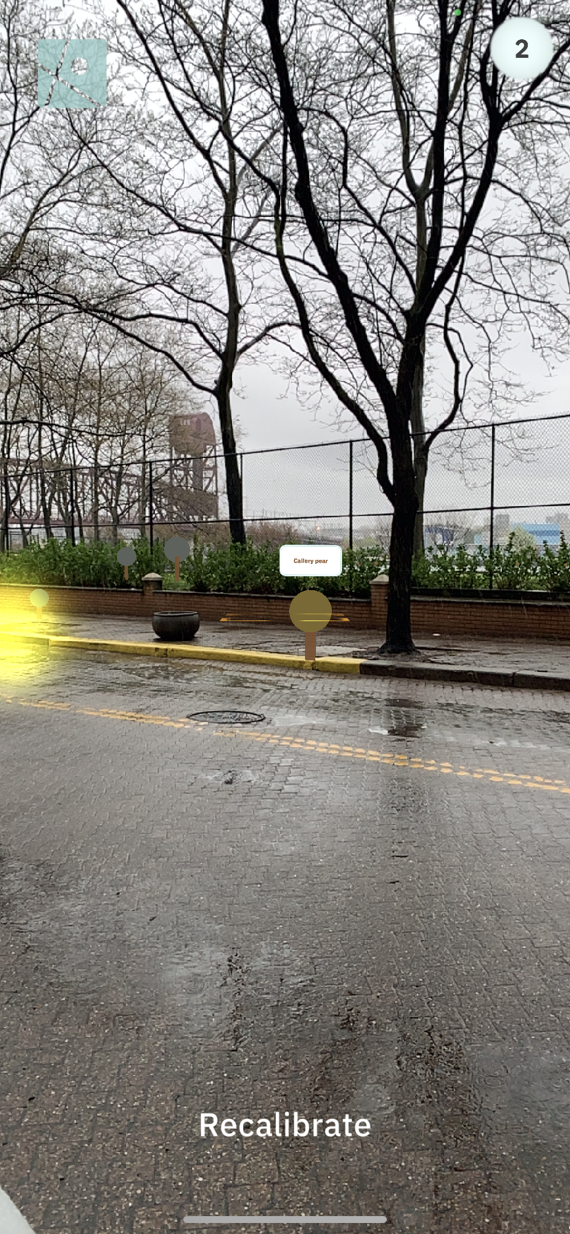
Explore climate indicators such as heat and flood risk in a novel 3D interactive mapping environment
Experiment with first person augmented reality on the streets of New York City
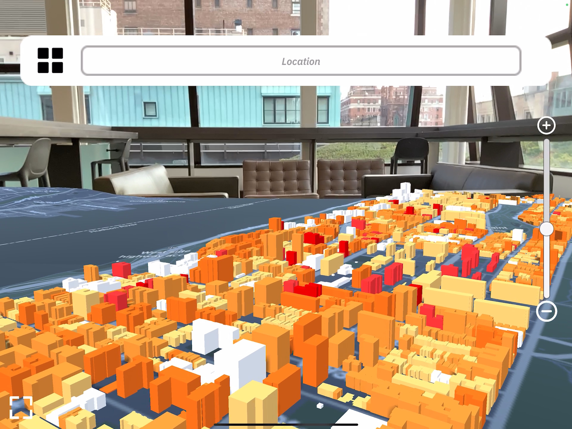
Project maps onto a physical surface displaying social, ecological and technological data layers with stakeholders and communities
View proposed green infrastructure projects and explore climate solutions
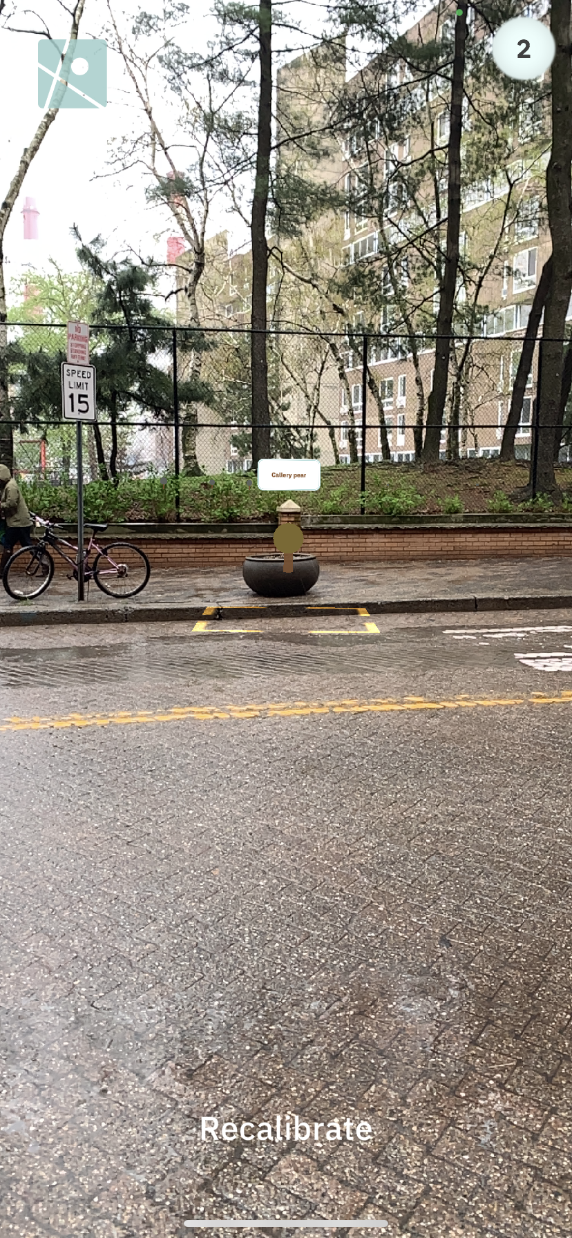
First-Person 3D Visualizations
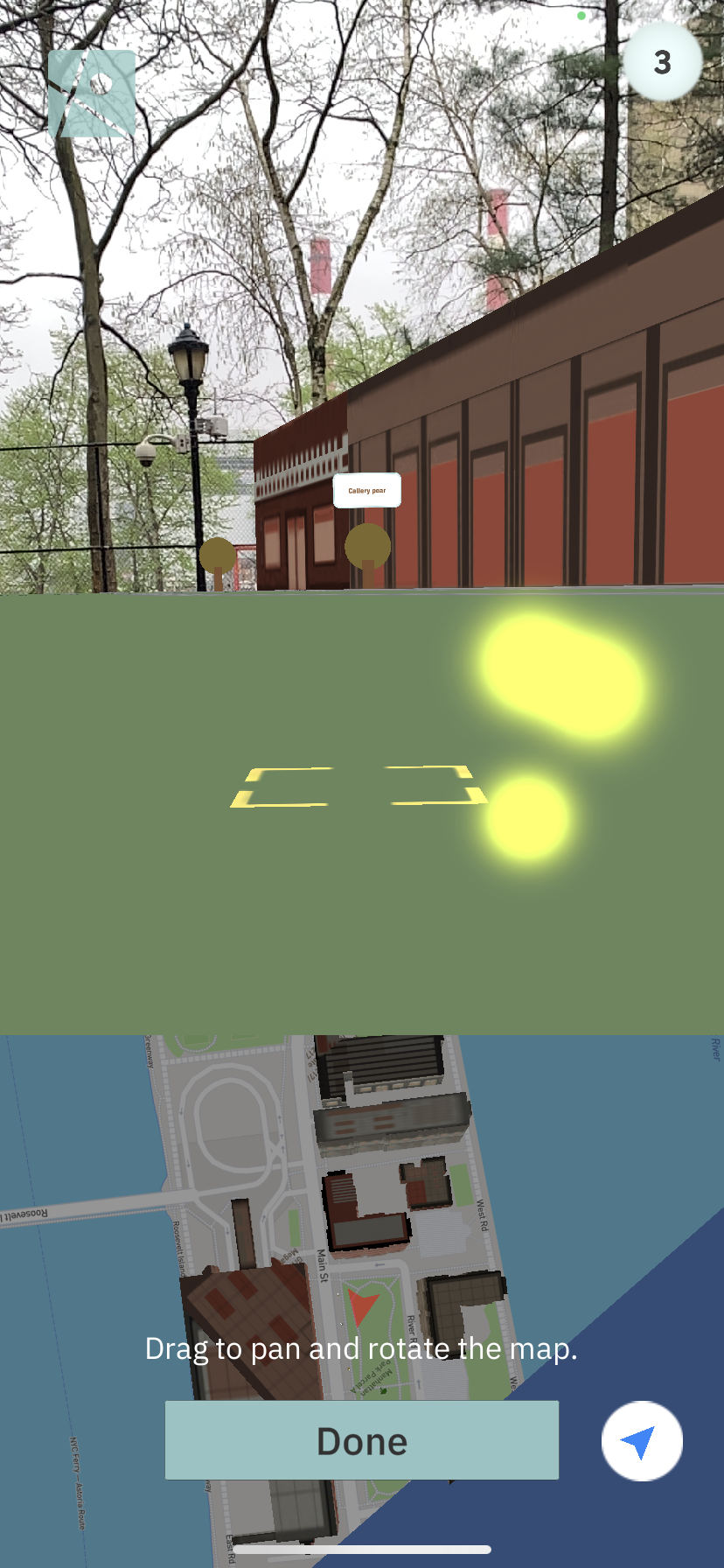
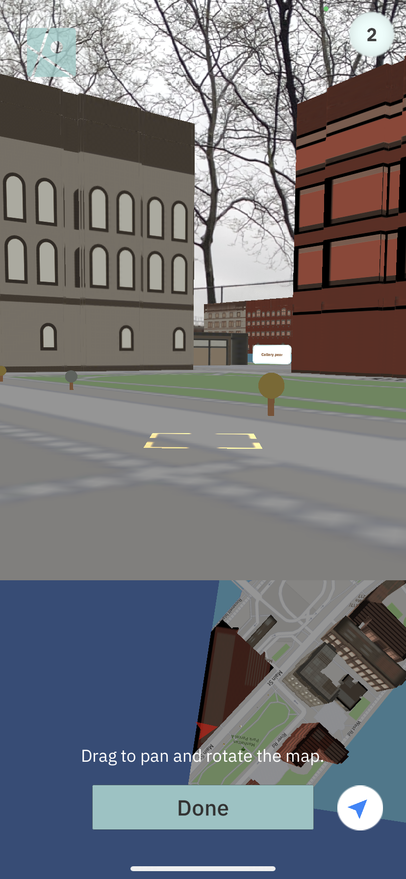
Augmented Reality Surface Projection Demo
Tile Query Prototype


Hosted Data
NYC surface temperature
Income per building
Floodplains
Green infrastructure
NYC Heat map
Redlining
PEJA boundaries
Hispanic population per building
Age of population at or above 65
Green roofs
NYC open space
NYC trees
Library locations
White population per building
Asian population per building
Black population per building
Key Variables
Climate Hazards: Current and future heat and coastal flood exposure (Variables: summer 2020 land surface temperature at 60m, future 2050 LST at RCP4.5 and 8.5 (may want to choose only 1, can also do 2100), Sandy 2012 coastal flood inundation, FEMA floodplain 2050 and 2100, 100yr and 500yr)
Climate Vulnerability: Social vulnerability (elderly >65yrs, income below poverty line, or just income highlighting low bracket, race/ethnicity, all from Census ) and critical infrastructure that is vulnerable (Hospitals, Schools, NYCHA properties (could expand list easily from data processed for NYC Stormwater Project)
Climate Solutions: Nature-based Solutions (street trees, bioswales, green roofs to start, perhaps to expand) and could look at other Infrastructure Solutions (cooling centers, libraries, if we have bandwidth)
Need for Ocellus XR
As cities face urgent social-ecological crises, there is an increasing need to rapidly respond with novel urban design interventions. NYC is investing in green infrastructure (~$1 Billion) in ways that will at minimum maintain the status quo in access to GI benefits and potentially create conditions for further social inequity. To date, there are few ways for communities to understand where, how, and when vulnerable populations are exposed to heat waves, coastal flooding, and inland flooding. Further complicating this, urban planners and architects do not have adequate tools for creating participatory processes to inform decision-making. Ocellus XR will partially address this need, bringing social, ecological, and infrastructure data together through an open source mobile app for exploration of where, how, and for whom to build resiliency. The aim is to help shift thinking and understanding around climate risk data at varying scales, view proposed resiliency efforts in real-time, and catalyze participatory planning processes. This may increase the speed for interventions and community feedback, improve scenario testing, aid in visualization and inform architectural practices for equitable adaptation in cities that center the voices of frontline communities.
Current Team

Daniel Sauter
Project Co-Director

Joe Steele
Technician

Elena Peng
Research Assistant

Timon McPhearson
Project Co-Director

Chris Kennedy
Project Coordinator

Claudia Tomateo
Designer
Previous Team Members

Peilu Fan
Research Assistant

Emily Bowe
Research Associate

John Outwater
Research Assistant

Saloni Shah
Research Assistant

Yahnze Wu
Research Assistant

Jeremy Odell
Research Assistant
Support and Acknowledgements
Ocellus XR is developed by members of the Urban Systems Lab at The New School. The current Ocellus XR team includes Urban Systems Lab associate director Daniel Sauter; USL director Timon McPhearson; Joe Steele, MS Data Visualization ’18; Xinyue Elena Peng, BFA Design & Technology ’22; and Schools of Public Engagement research fellow Claudia Tomateo; and Urban Systems Lab Associate Director Chris Kennedy. Support for OcellusXR is provided in part by the Architecture League of New York’s 2022 Independent Project Grant which is made possible through support from the New York State Council on the Arts.
The graphics, text and information included in the “What can I do?” section of Ocellus XR was developed by WE ACT for Environmental Justice, the East Harlem COAD and Harlem Emergency Network as part of the Climate Ready Uptown Plan (CRUP) project. CRUP is a physical pamphlet that helps Northern Manhattan community members understand their individual risk to climate related disasters and provides pertinent information to help prepare themselves and their families.
Please contact us if you are interested in learning more or collaborating.